Written by Simon Wilkins
South Croydon & South End runs along the valley to the south of central Croydon.
The area and its history are dominated by 4 main historic features. The main feature is Brighton Road running North to south with its many coaches stops and public houses.
Then we have the area of Croham Hurst (Crawham/Craweham – the office of first fruits & Tenths) which is mentioned and recorded both in 1225 & January 1366 by the national archives. Croham before being a farm was mostly woodland and is rumored to have had a manor house but it is not mentioned in the 1691 “Manor houses of Surrey” (as it may have been in Kent at the time) .The area has produced many historical finds from flint tools of Neolithic or New Stone Age man. It is said to have been a burial mound dating back to 2000 BC.
The other two are lesser known, with one only showing itself in stormy weather or every 7 years. The Bourne water way back in the times of King Henry IIIV & Elizabeth I would sometimes leave the area inaccessible through the winter months. Elizabeth I mentions it when visiting South Croydon “the water was found to come up to the horses Barrel” (belly). Yet it is still there hidden away within a culvert and can sometimes be heard at night just after a rainy day.
The other being the most prominent of the nearby Haling Manor with its 400 acres was (now Whitgift school grounds) once owned by Henry VIII. Haling manor is seen on maps from 1611. The house has long gone but pre doomsday it has been mentioned that there once stood a Royal palace & before that the top of the ground was home to a covenant of witches.
Haling House had many famous people living there from Charles Howard, the 1st Earl of Nottingham, and It was notable in Tudor times as the home to the now Lord Howard of Effingham, the Lord High Admiral of the Fleet sent against the Spanish Armada, and was host to a succession of royalty and notable visits.
It is worth noting that the Whitgift school’s weather is a Ship (the Ark Royal). His full coat of arms gives its name to the blue anchor public house.
It was also the family home of the Gages who were complicit in the Babington Plot. Robert Gage was executed 21 Sep1586 for his involvement in the Babington Plot and his younger son John was imprisoned in the Tower of London and is said to have been found hiding in the priest hole in Haling cottage.
Later the House became the residence for James Watney the brewers. With the ownership being in the name of Willaim Parker Hammond the second of Cambridgeshire. The Parker Hammonds father had owned the land and surrounding for many years before possibly suffering from lunacy. The land now known as Haling Park was used for Farming and often held poultry shows & even the Croydon fair in 1896. Alfred Bullock sold Fruit and vegetables from the site. It was also once a convent & boarding school for young girls & ladies.
The names of Manors, routes & features, the Cambridgeshire family and Archbishops plus the families of Battersea, Wandsworth & Croydon can still be seen in the area today, and the locations of the manor houses can be found in the Croham Manor Road conservation area and in Whitgift School. Much of the land of South Croydon has been associated through the years with the Whitgift.
From Warham, Haling, and the Hammonds of Cambridgeshire have left their mark on most of the area. Pampisford house in Cambridgeshire gives its name to the road. And Haling Park Road was once called Parker Hammond Road. The red deer was part of the Hammond coat of arms.
The area was newly developed in the 19th century following the railways and its stations. As both lands of the two ancient manors, Croham and Haling were sold off. In 1931 Haling Park Land in South Croydon was purchased and became the home of the Whitgift School.
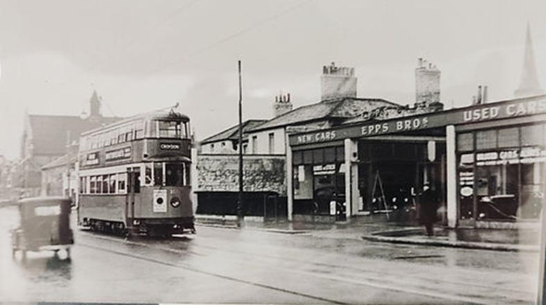
South End has and has had many historical buildings & landmarks. It was once the site for a Croydon to Reigate turnpike (abolished in 1829). This would have been a busy area with the mail coaches passing every 7 minutes in winter and King George IV. in his heavy carriage, attended by a troop of lancers on their way to the Brighton pavilion.
And Both the Blue anchor & Swan and sugar loaf can be traced back to the 1800 century. These were great sites for sport and pleasure, holding boxing matches in the 1780s to meeting places for hunts and to watch the passing steeple chases from Smitham Bottom to Broad green.
The foundation stone for St Peter’s church was laid by Mr. Smith of Selsdon House on 12 September 1849 and consecrated 18 September 1851. The church was designed by Sir Gilbert Scott and built for £6600. The spire was damaged by a fire caused by a break in in 1864, causing £1600 worth of damage.
St Peters has pride of place as it overlooks South End from land once owned by John Ruskin. It is hard to imagine yet it was outshone by the then magnificents of Blunt house & its clock house. Blunt House was home to the Scots and one source of the Wandle which bubbled up in the garden. It is a crying shame that it was demolished in the 1880s. John Oldrid Scot (son of Gilbert) took many of the features to his new Oxted Home including chimneys & fireplaces. Yet he did gift the clock to St Augustine’s church which in time has disappeared.
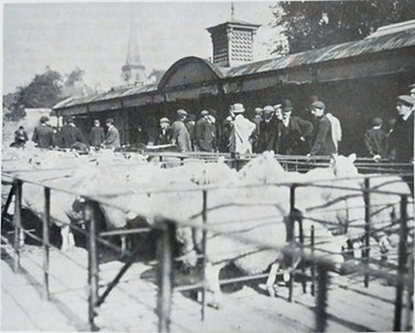
Drovers road is thought of as a place of cattle and once there was a livestock market you could get most types of animals associated with farming from Cattle, sheep, ducks, rabbit and horses, but it was also a place where you could purchase gravel, Loam soil, turf & peat. It opened in 1848 and closed in 1935.
South Croydon
The most prevalent building south of the area surely is Whitgift school & St Augustine’s church. St Augustine was designed by John Oldrid Scot from Blunt house and funded by gifts from all including Parker Hammond & Susan Courage (brewers). Rev John White first proposed the sister church in July 1880. It is said that there was a need for a new church as the Area was growing and land was being released to market by Parker Hammond.
Yet it is worth noting that St Peters graveyard was near full & some members of the committee did not agree, and in fact commented that St peters was “always unoccupied at each service.”
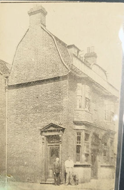
But we must not forget Crunden Place or Snobs Island, Crunden place was demolished to make way for a stormwater tank and the bus garage. It was the site of a group of farm buildings and said to be where the fox hounds were stationed.
Snobs Island refers to Bynes Road & Rolleston Road, the word ‘snob’ dates from the late 19th century meaning shoemaker. The road name Rolleston has been lost in time, but there was a Rolleston Family living in Croydon at the time of the building of the road. Bynes road gets its name as the land was owned by the Byne Family from Sussex and Carshalton.
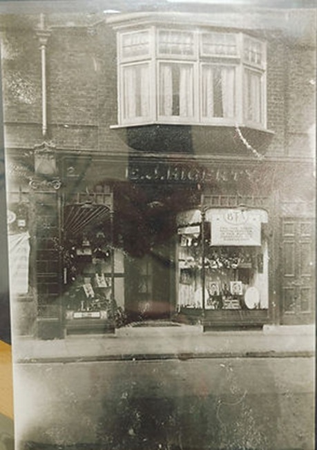
John Cooper the owner of the Steam boot factory situated in Lower coombe road. Cooper (the second) made his money by introducing a weekly payment system for his boots at a time when they were most needed. So, he purchased the land that backed onto the railway and built the houses to rent to his shoemakers in Bynes & Rolleston Rd. The shoemakers would work from home on a piece meal kind of no hour’s contract.
William Fowler Taylor had an oil cloth factory (linoleum) in Wyche Road and Purley Road. The factory was where the doctor’s surgery is and stretched as the site of St Gertrude’s. Taylor lived in Purley cottages in Purley road, and if you look you can see remnants of the old flint walls. Taylor and the factory had a bad reputation, there were several complaints regarding working conditions & the smell, yet he would always plead poverty. Taylor went on to build many houses in the roads in and around the factory including Taylor Cottages on the Brighton Road. The Taylor designs that remain are quite impressive and can be viewed at the national archives.
I can’t finish without mentioning both the surrey Iron railway & “The Brighton Road Council school.”
The Surrey Iron Rail was the first public railway. It was designed to allow anyone with their own horses and rail cart to transport all manner of goods. It serviced the chalk & lime Kilns at the Royal oak, and also brought in the stone for Croydon’s High Street town hall. The exact route is unknown, but traces of it can be seen on even modern of maps.
Brighton Road Council school, starting in 1874 and now known as Purley Oaks. It provided schooling for the children of Snobs Island and the Taylor factory. The school did struggle but credit has to be given to the Heads of the time as well as Susan Courage and her daughters. The Courages helped no end by buying shoes, Musical instruments and school dinners. The Courage daughters also taught needle work to the Girls who went on to sell their wares for extra money.
The school and the pupils went on to suffer many times in the second world war. The area was bomber many times possible due to the railway, Bus garage and the aerodrome. On one occasion any unexploded bomb that had landed nearby detonated while being loaded into a truck killing all 6 engineers.
Famous people
Alfred Russel Wallace (1823–1913)
Found at: 44 St Peter’s Road, South Croydon CR0 1RG.
Alfred Russel Wallace was a British naturalist, explorer and geographer whose work is associated with Charles Darwin, as both wrote on the theory of evolution through natural selection.
John Horniman (1803–1893) and Frederick John Horniman (1835–1906)
Found at: Coombe Cliff, Coombe Road, Croydon CR0 5SP.
John Horniman and his son Frederick John Horniman were the founders of Horniman’s Tea, a tea business that used mechanical packaging and grew to be the biggest tea company in the world. South London locals may recognise this name as Frederick John Horniman founded the Horniman Museum in Forest Hill.
William Ford Robinson Stanley (1829-1909)
Inventor of the lemon squeezer and wire bicycle spoke.